Understanding Map Questions in IELTS Task 1
Map questions have always been popular in IELTS, so I thought it would be a good idea to look at this IELTS Task 1 question.

You can find the original map and a suggested answer in Cambridge Practice Test for IELTS 1
There are 2 types of map in IELTS:
- A map that shows a comparison and
- A map that shows development of an area.
In this post, I am going to look at the second one, a development of an area and then consider a comparison.
What information do IELTS development maps show?
Development maps often show a number of changes over a number of dates.
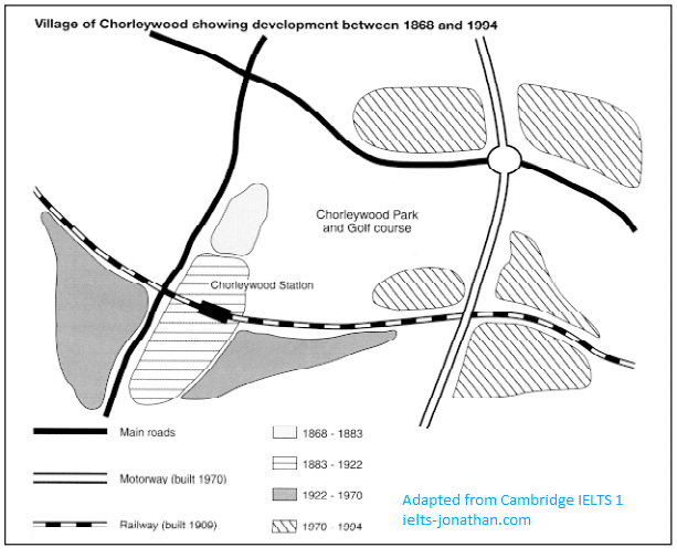
Often there is just one image and you will need to read and understand the key to be able to describe the developments.
In this example, there is a key to show types of changes.
You can see that in this example there are road and rail changes.
There is also a key to indicate the time periods.
Notice that there are four time periods in this example.
Periods are different to dates, which are finished.
Periods indicate that there were developments, for example, between 1883 and 1922.
By studying the periods, we can understand the development of areas and then report these logically.
Chorleywood is a village near London whose population has increased steadily since the middle of the nineteenth century.
The map below shows the development of the village.
Write a report for a university teacher describing the development of the village.
You should write at least 150 words
Cambridge Practice Test for IELTS 1 (1995)
How to best answer the question.
This map looks complicated.

In my opinion, the best way to attempt this question is to start with
a simple introduction,
follow this up with an overview so the reader can understand the major point
and then talk about the changes over time.
I think it would be logical to divide the dates into two paragraphs.
To help you consider how to describe the map, answer these questions:
- How could you paraphrase “the map shows the development of the village”?
- How many periods of development are shown, and which period saw the most change and development?
- Is there a relationship between transport and the growth of the village?
- How could you group the information in order to write two ‘specific details’ paragraphs?
Band 9 Example essay
Here is my full answer (band 9):
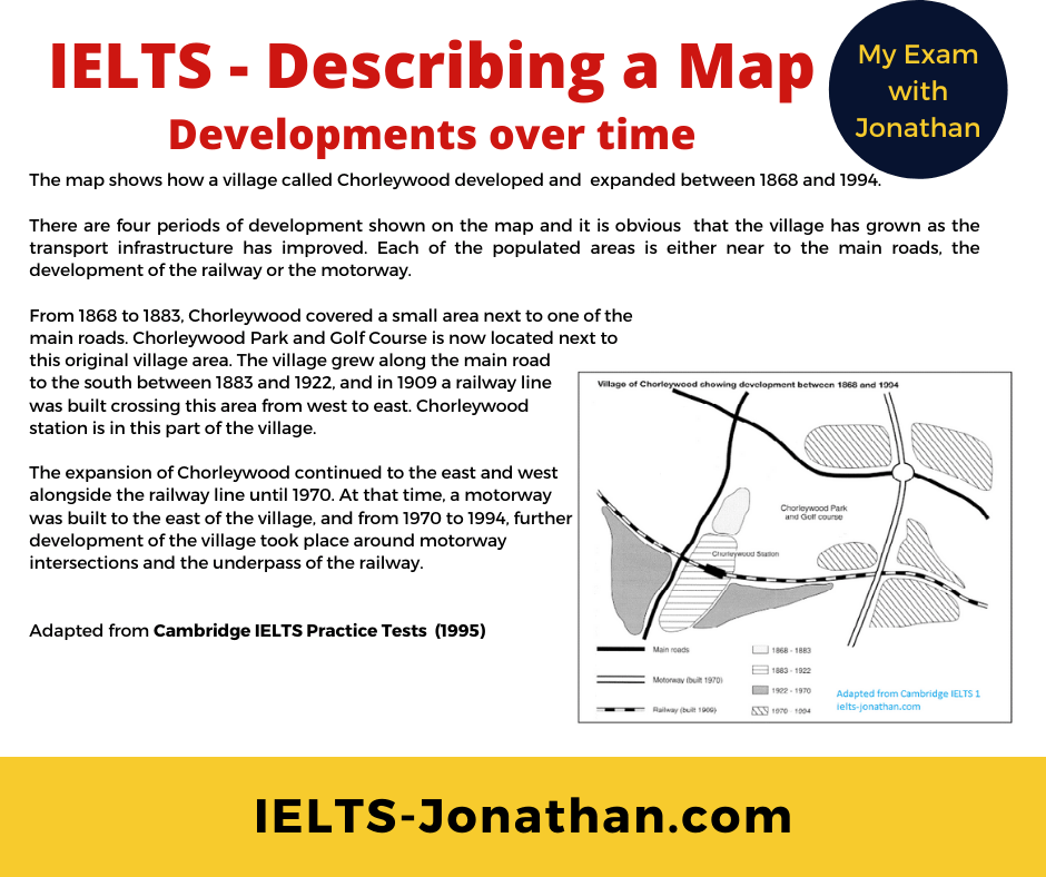
The map shows how a village called Chorleywood developed and expanded between 1868 and 1994.
There are four periods of development shown on the map and it is obvious that the village has grown as the transport infrastructure has improved. Each of the populated areas is either near to the main roads, the development of the railway or the motorway.
From 1868 to 1883, Chorleywood covered a small area next to one of the main roads. Chorleywood Park and Golf Course is now located next to this original village area. The village grew along the main road to the south between 1883 and 1922, and in 1909 a railway line was built crossing this area from west to east. Chorleywood station is in this part of the village.
The expansion of Chorleywood continued to the east and west alongside the railway line until 1970. At that time, a motorway was built to the east of the village, and from 1970 to 1994, further development of the village took place around motorway intersections and the underpass of the railway.
Remember that Band 9 essays are written by trained material writers and language specialists.
These examples are generally an unrealistic expectation for most students.
The key is to notice the main features and include them AND the overview in your writing to have a chance of a Band 6.
Answering a real IELTS Map question – Comparisons and Developments
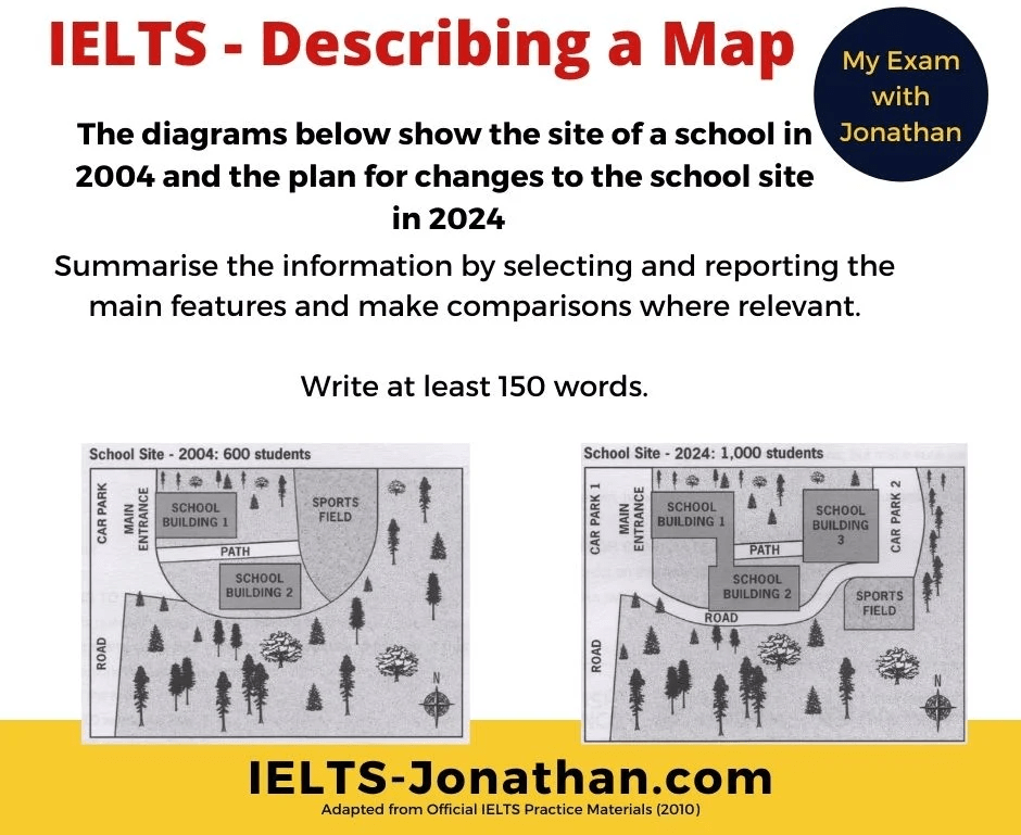
Here’s another map to work with but this time it refers to changes that are planned or predicted.
Notice there are two time periods, 2004 and 2024.
The main focus is comparing the changes that, in this case, will happen.
While it is important to pay attention to your grammar choices, you still need to focus on comparing the changes to meet the task requirements.
The original question materials can be found in Official IELTS Practice Materials 2
The diagrams below show the site of a school in 2004 and the plan for changes to the school site in 2024.
Summarise the information by selecting and reporting the main features and make comparisons were relevant.
It’s a good idea to follow the same process with any map or plan.
When you are thinking about describing the map, try using these questions to generate ideas and language:
- How could you paraphrase “the diagrams below show the site of a school”?
- How many changes are shown, and what are the most significant changes to the map?
- Is there a relationship between changes in development and the growth of the school site?
- How could you group the information in order to write two ‘specific details’ paragraphs?
If you want more tips on answering this question, follow this post.
IELTS Writing about Maps for Task 1
For information on the language for comparing and contrasting, follow this post.
Language to describe changes in IELTS maps.
How I studied and wrote my IELTS response for this task
I wrote my response to this task by doing the following.
I studied the two maps and the question.
I noted any dates and then noted that I would need to use the past simple for the 2004 map, and then noted I could use a number of future tenses for the planned school in 2024.
I also noted any important numbers such as 600 students and the predicted number of 1000 in 2024.
I also made a mental note that using passive sentence constructions are probably the most appropriate for this task, as the agent (the builder, the planner etc) is not important.
I then carefully looked at the map in the past (remember we don’t know, and are not interested in how the map looks in the present) and made a mental checklist, like this:
A road, a car park and the main entrance in the east
Two school buildings in the centre named 1 and 2
A path running from the main entrance to the playing/sports field
Significant wooded areas to the south and the west of the school
Doing this made it easier to note the changes that are planned or predicted.
I first of all noted the aspects that remained the same, such as the road, the car park and the main entrance in the east.
I could then go on to talk about the changes that will happen.
I was able to mention that the sports field will become smaller, and that an additional school building will be built.
I was able to see that the existing school buildings are now connected by a corridor or a passageway, and this has resulted in the path that connected the main entrance and the sports field being changed.
It has been shortened so that it connects the school building 3 with school building 1 and 2.
This is probably better for students in the winter or in the rain but I decided not to include this detail in my writing.
After that I was able to say that the sports field has been made smaller and its location has moved and I was able to say why.
This is to accommodate school building 3, and to accommodate a new car park called carpark 2.
I was careful to mention all the changes and I considered that it is important to say that part of the wooded area has been removed to allow for these changes.
I did not spend too much time on the introduction but paraphrased as much as I could.
More important was that I wrote a strong overview – namely that additions to the school will result in reductions.
Of course, once I finished my writing I counted the words and spent about 5 minutes proofreading my writing for errors in spelling, punctuation and grammar before I was satisfied. 🙂
Band 9 example essay – school development plan
Don’t forget that this essay was written by a trained language specialist so just note that it mentions all the features and includes a clear overview.
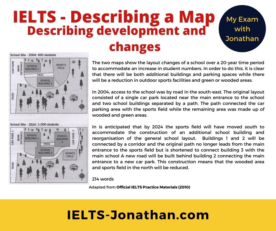
The two maps show the layout changes of a school over a 20-year time period to accommodate an increase in student numbers.
In order to do this, it is clear that there will be both additional buildings and parking spaces while there will be a reduction in outdoor sports facilities and green or wooded areas.
In 2004, access to the school was by road in the south-east. The original layout consisted of a single car park located near the main entrance to the school and two school buildings separated by a path. The path connected the car parking area with the sports field while the remaining area was made up of wooded and green areas.
In is anticipated that by 2024 the sports field will have moved south to accommodate the construction of an additional school building and reorganisation of the general school layout. Buildings 1 and 2 will be connected by a corridor and the original path no longer leads from the main entrance to the sports field but is shortened to connect building 3 with the main school A new road will be built behind building 2 connecting the main entrance to a new car park. This construction means that the wooded area and sports field in the north will be reduced.
You can use tips and information on this website to help make it easier to obtain a higher score.
Remember you still need to work at learning the language to be successful.
Leave a comment for a reply!
Good Luck
Jonathan
I’m Jonathan
I’ve taught IELTS and University English in more than a dozen universities and schools around the world.
I’m a parent, traveller and passionate about language teaching and helping students achieve their dreams.
Whilst living in Austria or working in Asia, I run IELTS courses to help students get to where they want to be.
If you are serious about IELTS, connect with me to see how I can help you.


Was this helpful? Leave a comment :)